
This is an old revision of the document!
Areas Excluded from Dredging
Areas Excluded from Dredging
The River Tees has a heavy industrial history of over 150 years and because of this has one of the most contaminated riverbed sediments of any port in the UK.
While the names of excluded areas where the river was considered too toxic to dredge were specified in both MLA/2025/00263 and the previous 10 year licence application MLA/2015/00088, the exact coordinates were not specified. These were added after MLA/2025/00263 was granted when a judicial review highlighted this error in granting the licence.
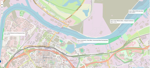
The total area excluded from dredging is less than 1% of the total area currently licenced to be dredged MLA/2025/00263.
| # | Name | Area Ha |
|---|---|---|
| 1 | Britannia Wharf and Enterprise Zone | 0.80 |
| 2 | Cochranes Tees Wharf - Normanby Wharf Graving Dock | 7.83 |
| 3 | Tees Offshore Base - Tees Commerce | 1.13 |
| 4 | Wharf(TPC) Dry Dock | 0.85 |
| All | Total Area | 10.61 |
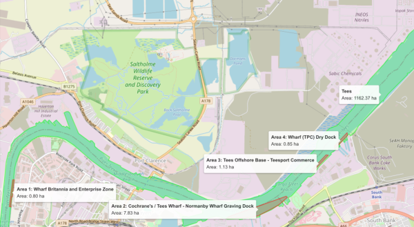
The smallest excluded area is Britannia Wharf and Enterprise Zone is only 0.8Ha.
| Dredge Parameter | Value |
|---|---|
| Total dredged area of the River Tees | 1162.37Ha |
| Total excluded area from dredging | 10.61Ha |
| % of total dredged area excluded | 0.91% |
| Area of smallest excluded area | 0.8Ha |
| % of total dredged area made up by smallest excluded area | 0.07% |
| Number of times smallest excluded area fits into total dredge area | 1453 |
The total currently licenced dredge area is 1,453 times the size of the smallest area excluded. Looking for contamination localised at this scale in the licenced dredge area is very much the proverbial looking for a needle in a haystack.
This is explored more fully as the River Tees Contamination, Excluded Areas and Sampling.